


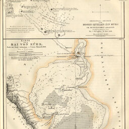
Karte der Bai von Súes nach der Engl. Aufnahme
Permalink
https://digital.library.illinois.edu/items/59c3a3b0-e946-0133-1d3d-0050569601ca-7
This item is in the public domain.
Descriptive Information
| Title | Karte der Bai von Súes nach der Engl. Aufnahme |
| Creator | Petermann, A. (August), 1822-1878 |
| Date | 1861 |
| Dimensions | 16.1 x 19 cm |
| Place of Publication | Germany |
| Cartographic Scale | 1:140,000 |
| Notes | Relief shown by hachures, depths shown by soundings. |
| Coverage-Spatial | Egypt |
| Subject | |
| Genre | Maps |
| Language | German |
| Color | Hand colored |
| Technique | Lithography |
| Source | Petermanns geographische Mitteilungen, V. 7, plate 15. |
| Physical Location | stx |
| Map No. in Bassett and Scheven Bibliography | 727 |
| Call Number | Q_910_5PE |
| Map ID | afm0000727 |
| Rights | No Copyright - United States |
| Rights Description | This item is in the public domain. |
| Collection Title | Maps of Africa to 1900 |
| Repository | Rare Book & Manuscript Library |
| Type | Cartographic material |
| Collection | Maps of Africa to 1900 |
Download Options
|
Karte der Bai von Súes nach der Engl. Aufnahme |
Contact us
for questions and to provide feedback.