
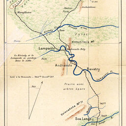
Itinéraire du Morondava au Mangoky du 1er. Août au 7 Septembre 1891
Permalink
https://digital.library.illinois.edu/items/59e71290-e946-0133-1d3d-0050569601ca-a
This item is in the public domain.
Descriptive Information
| Title | Itinéraire du Morondava au Mangoky du 1er. Août au 7 Septembre 1891 |
| Creator | Douliot, H. |
| Date | 1891 |
| Dimensions | 13.5 x 42.1 cm |
| Place of Publication | France |
| Cartographic Scale | 1:450,000 |
| Notes | Relief shown by shading and spot heights. Includes 1 inset location map: Ile de Madagascar. |
| Coverage-Spatial | Mangoky River (Madagascar) |
| Subject | |
| Genre | Maps |
| Language | French |
| Color | Printed color |
| Technique | Lithography |
| Source | Annales de géographie : bulletin de la Société de géographie, V. 1, between pp. 248-249. |
| Physical Location | stx |
| Map No. in Bassett and Scheven Bibliography | 1373 |
| Call Number | 910_5AN |
| Map ID | afm0001373 |
| Rights | No Copyright - United States |
| Rights Description | This item is in the public domain. |
| Collection Title | Maps of Africa to 1900 |
| Repository | Rare Book & Manuscript Library |
| Type | Cartographic material |
| Collection | Maps of Africa to 1900 |
Download Options
|
Itinéraire du Morondava au Mangoky du 1er. Août au 7 Septembre 1891 |
Contact us
for questions and to provide feedback.