
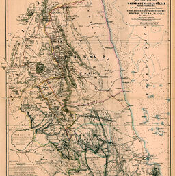
Originalkarte von Werner Munzinger's Erforschung der gebiete der Habab-& Beni-Amer-Völkeer Januar-Oktober 1871...Nord-Abessinischen Grenzländer, Bogos, Mensa, Marea.
Permalink
https://digital.library.illinois.edu/items/5a8d5e80-e946-0133-1d3d-0050569601ca-5
This item is in the public domain.
Descriptive Information
| Title | Originalkarte von Werner Munzinger's Erforschung der gebiete der Habab-& Beni-Amer-Völkeer Januar-Oktober 1871...Nord-Abessinischen Grenzländer, Bogos, Mensa, Marea. |
| Creator | Petermann, A. (August), 1822-1878 |
| Date | 1872 |
| Dimensions | 51.5 x 42.7 cm |
| Place of Publication | Germany |
| Cartographic Scale | 1:500,000 |
| Notes | Relief shown by contoured hachures, depths shown by soundings. |
| Coverage-Spatial | Abyssinia |
| Subject | |
| Genre | Maps |
| Language | German |
| Color | Hand colored |
| Technique | Lithography |
| Source | Petermanns geographische Mitteilungen, V. 18, plate 12. |
| Physical Location | stx |
| Map No. in Bassett and Scheven Bibliography | 1151 |
| Call Number | Q_910_5PE |
| Map ID | afm0001151 |
| Rights | No Copyright - United States |
| Rights Description | This item is in the public domain. |
| Collection Title | Maps of Africa to 1900 |
| Repository | Rare Book & Manuscript Library |
| Type | Cartographic material |
| Collection | Maps of Africa to 1900 |
Download Options
|
Originalkarte von Werner Munzinger's Erforschung der gebiete der Habab-& Beni-Amer-Völkeer Januar-Oktober 1871...Nord-Abessinischen Grenzländer, Bogos, Mensa, Marea. |
Contact us
for questions and to provide feedback.