
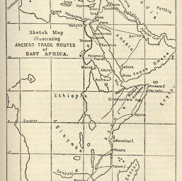
Sketch Map Illustrating Ancient Trade Routes of East Africa
Permalink
https://digital.library.illinois.edu/items/5ac8b6d0-e946-0133-1d3d-0050569601ca-1
This item is in the public domain.
Descriptive Information
| Title | Sketch Map Illustrating Ancient Trade Routes of East Africa |
| Creator | O'Neill, H. E. (Henry Edward), 1848-1925 |
| Date | 1886 |
| Dimensions | 14.2 x 11.5 cm |
| Place of Publication | England |
| Cartographic Scale | 1:50,000,000 |
| Coverage-Spatial | Africa, East |
| Subject | |
| Genre | Maps |
| Language | English |
| Color | Bitonal |
| Technique | Lithography |
| Source | Scottish geographical magazine, V. 2, p. 93. |
| Physical Location | stx |
| Map No. in Bassett and Scheven Bibliography | 348 |
| Call Number | 910_5SC |
| Map ID | afm0000348 |
| Rights | No Copyright - United States |
| Rights Description | This item is in the public domain. |
| Collection Title | Maps of Africa to 1900 |
| Repository | Rare Book & Manuscript Library |
| Type | Cartographic material |
| Collection | Maps of Africa to 1900 |
Download Options
|
Sketch Map Illustrating Ancient Trade Routes of East Africa |
Contact us
for questions and to provide feedback.