
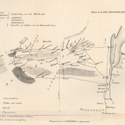
Kaartje van het binnenland achter Inhambane
Permalink
https://digital.library.illinois.edu/items/5b039720-e946-0133-1d3d-0050569601ca-1
This item is in the public domain.
Descriptive Information
| Title | Kaartje van het binnenland achter Inhambane |
| Creator | Brinkman, C.L. |
| Date | 1887 |
| Dimensions | 18.6 x 26.5 cm |
| Cartographic Scale | No scale |
| Notes | Needs repair. |
| Coverage-Spatial | Africa, Eastern |
| Genre | Maps |
| Color | Bitonal |
| Technique | Lithography |
| Source | Tijdschrift, series 2, V. 4, section 2, between pp. 204-205. |
| Physical Location | stx |
| Map No. in Bassett and Scheven Bibliography | 1301 |
| Call Number | 910_6NESER_2 |
| Map ID | afm0001301 |
| Rights | No Copyright - United States |
| Rights Description | This item is in the public domain. |
| Collection Title | Maps of Africa to 1900 |
| Repository | Rare Book & Manuscript Library |
| Type | Cartographic material |
| Collection | Maps of Africa to 1900 |
Download Options
|
Kaartje van het binnenland achter Inhambane |
Contact us
for questions and to provide feedback.