
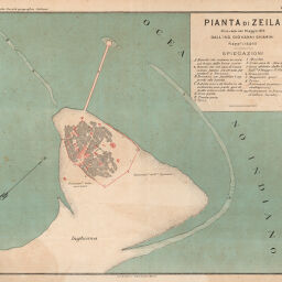
Printa di Zeila relivata nel Maggio 1876 dall' IngGiovanni Chiarini
Permalink
https://digital.library.illinois.edu/items/5bfd9f00-e946-0133-1d3d-0050569601ca-e
This item is in the public domain.
Descriptive Information
| Title | Printa di Zeila relivata nel Maggio 1876 dall' IngGiovanni Chiarini |
| Creator | Società Geografica Italiana |
| Date | 1878 |
| Dimensions | 26 x 21.5 cm |
| Place of Publication | Italy |
| Cartographic Scale | 1:10,000 |
| Notes | Incorrect title given, correct title is Pianta di Zeila relivata nel Maggio 1876 dall' Ing. Giovanni Chiarini. |
| Coverage-Spatial | Africa, Eastern |
| Genre | Maps |
| Color | Printed color |
| Technique | Lithography |
| Source | Bollettino della Societa geografica italiana, ser. 2, V. 3, between pp. 160-161. |
| Physical Location | stx |
| Map No. in Bassett and Scheven Bibliography | 1203 |
| Call Number | 910_6SORSER_2 |
| Map ID | afm0001203 |
| Rights | No Copyright - United States |
| Rights Description | This item is in the public domain. |
| Collection Title | Maps of Africa to 1900 |
| Repository | Rare Book & Manuscript Library |
| Type | Cartographic material |
| Collection | Maps of Africa to 1900 |
Download Options
|
Printa di Zeila relivata nel Maggio 1876 dall' IngGiovanni Chiarini |
Contact us
for questions and to provide feedback.