
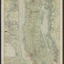
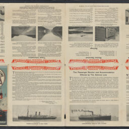
Maps showing routes of the Pacific Steamship Co.
Permalink
https://digital.library.illinois.edu/items/64bee740-4e09-013e-321b-02d0d7bfd6e4-0
This item is in the public domain.
Descriptive Information
| Title | Maps showing routes of the Pacific Steamship Co. |
| Alternative Title |
|
| Creator | Admiral Line |
| Contributor | Poole Brothers |
| Scale | Scales differ |
| Place of Publication | Chicago (Ill.) |
| Publisher | Admiral Line |
| Date of Publication | 1918 |
| Extent | 8 color maps on 1 sheet : color |
| Dimensions | 73 x 30 cm or smaller, on sheet 83 x 45 cm, folded to 23 x 11 cm |
| Notes |
|
| Coverage-Spatial | |
| Language | English |
| Subject | |
| Genre | |
| Rights | No Copyright - United States |
| Rights Description | This item is in the public domain. |
| Type | Cartographic material |
| Repository | Map Library |
| Local Bib ID | 99955653006105899 |
| Collection Title | World War I Maps |
| Collection | World War I Maps |
Download Options
|
99955653006105899-00000001 | |
|
99955653006105899-00000002 |
Contact us
for questions and to provide feedback.