
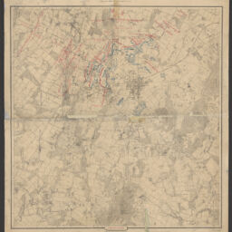
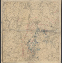
Map of the battle field of Gettysburg, July 1st, 2nd, 3rd 1863
Permalink
https://digital.library.illinois.edu/items/65b4d860-ba7a-013d-5129-02d0d7bfd6e4-c
This item is in the public domain.
Descriptive Information
| Title | Map of the battle field of Gettysburg, July 1st, 2nd, 3rd 1863 |
| Creator | Bachelder, John B. 1825-1894 |
| Contributor | Warren, Gouverneur Kemble, 1830-1882 |
| Scale | Scale [ca. 1:12,000]. 1 in. represents 1000 ft. |
| Place of Publication |
|
| Publisher | Authority of the Hon. Secretary of War in the office of the Chief of Engineers, U.S. Army |
| Date of Publication | 1876 |
| Extent | 3 maps : color, mounted on cloth |
| Dimensions | 72 x 68 cm |
| Notes |
|
| Coverage-Spatial | United States |
| Language | English |
| Subject | |
| Associated Entities | United States. Army. Corps of Engineers. |
| Genre | Maps |
| Rights | No Copyright - United States |
| Rights Description | This item is in the public domain. |
| Type | Cartographic material |
| Repository | Map Library |
| Local Bib ID | 99161985312205899 |
| Collection Title | Civil War Maps |
| Collection | Civil War Maps |
Download Options
|
99162132812205899-00000001 | |
|
99162132812205899-00000002 |
Contact us
for questions and to provide feedback.