
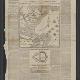
The entrance to Savannah River : scene of the encounter between the Union gunboats and the Rebel Tatnall's mosquito fleet, Thursday, Nov. 26, the Rebel fleet driven back
Permalink
https://digital.library.illinois.edu/items/65cc1430-ba7a-013d-5129-02d0d7bfd6e4-2
This item is in the public domain.
Descriptive Information
| Title | The entrance to Savannah River : scene of the encounter between the Union gunboats and the Rebel Tatnall's mosquito fleet, Thursday, Nov. 26, the Rebel fleet driven back |
| Creator | New York Herald Company |
| Scale | Scale approxiamtely 1:49,000 |
| Place of Publication | New York (N.Y.) |
| Publisher | |
| Date of Publication | 1861-12-03 |
| Extent | 1 map |
| Dimensions | 24 x 23 cm |
| Notes |
|
| Coverage-Spatial | |
| Language | English |
| Subject | |
| Associated Entities | B. & H. (Firm : New York, N.Y.) |
| Genre | Maps |
| Rights | No Copyright - United States |
| Rights Description | This item is in the public domain. |
| Type | Cartographic material |
| Repository | Map Library |
| Local Bib ID | 99955570414305899 |
| Collection Title | Civil War Maps |
| Collection | Civil War Maps |
Download Options
|
The entrance to Savannah River : scene of the encounter between the Union gunboats and the Rebel Tatnall's mosquito fleet, Thursday, Nov. 26, the Rebel fleet driven back |
Contact us
for questions and to provide feedback.