


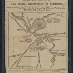
The Rebel stronghold in Kentucky : map of Bowling Green, with the surrounding hills and fortifications, the work before General Buell
Permalink
https://digital.library.illinois.edu/items/65d1fc50-ba7a-013d-5129-02d0d7bfd6e4-7
This item is in the public domain.
Descriptive Information
| Title | The Rebel stronghold in Kentucky : map of Bowling Green, with the surrounding hills and fortifications, the work before General Buell |
| Creator | New York Herald Company |
| Scale | Scale approximately 1:41,000 |
| Place of Publication | New York (N.Y.) |
| Publisher | New York herald |
| Date of Publication | 1862-01-14 |
| Extent | 1 map |
| Dimensions | 23 x 24 cm |
| Notes |
|
| Coverage-Spatial | Bowling Green (Ky.) |
| Language | English |
| Subject | |
| Genre | Maps |
| Rights | No Copyright - United States |
| Rights Description | This item is in the public domain. |
| Type | Cartographic material |
| Repository | Map Library |
| Local Bib ID | 99955570505905899 |
| Collection Title | Civil War Maps |
| Collection | Civil War Maps |
Download Options
|
The Rebel stronghold in Kentucky : map of Bowling Green, with the surrounding hills and fortifications, the work before General Buell |
Contact us
for questions and to provide feedback.