
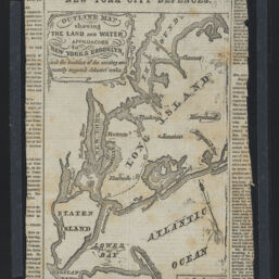
New York City defences : outline map showing the land and water approaches to New York & Brooklyn and the localities of the existing and recently suggested defensive works
Permalink
https://digital.library.illinois.edu/items/65de4ed0-ba7a-013d-5129-02d0d7bfd6e4-b
This item is in the public domain.
Descriptive Information
| Title | New York City defences : outline map showing the land and water approaches to New York & Brooklyn and the localities of the existing and recently suggested defensive works |
| Creator | New York Herald Company |
| Scale | Scale approximately 1:380,160. 1 inch to 6 miles nearly |
| Place of Publication | New York (N.Y.) |
| Publisher | New York herald |
| Date of Publication | 1861-07-01 |
| Extent | 1 map |
| Dimensions | 19 x 12 cm |
| Notes |
|
| Coverage-Spatial | New York (N.Y.) |
| Language | English |
| Subject | |
| Genre | Maps |
| Rights | No Copyright - United States |
| Rights Description | This item is in the public domain. |
| Type | Cartographic material |
| Repository | Map Library |
| Local Bib ID | 99955570721305899 |
| Collection Title | Civil War Maps |
| Collection | Civil War Maps |
Download Options
|
New York City defences : outline map showing the land and water approaches to New York & Brooklyn and the localities of the existing and recently suggested defensive works |
Contact us
for questions and to provide feedback.