
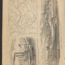
Birds-eye view of the Mississippi River and the adjacent country, from St. Louis to the Gulf of Mexico
Permalink
https://digital.library.illinois.edu/items/66906810-ba7a-013d-5129-02d0d7bfd6e4-0
This item is in the public domain.
Descriptive Information
| Title | Birds-eye view of the Mississippi River and the adjacent country, from St. Louis to the Gulf of Mexico |
| Alternative Title | On verso: Scenes of camp and army life in General Williams's brigade |
| Scale | Scale not given |
| Place of Publication | New York (N.Y.) |
| Publisher | Harper's weekly |
| Date of Publication | 1861-07-06 |
| Extent | 1 view |
| Dimensions | 35 x 24 cm |
| Notes |
|
| Coverage-Spatial | |
| Language | English |
| Subject | |
| Genre | |
| Rights | No Copyright - United States |
| Rights Description | This item is in the public domain. |
| Type | Cartographic material |
| Repository | Map Library |
| Local Bib ID | 99955575426205899 |
| Collection Title | Civil War Maps |
| Collection | Civil War Maps |
Download Options

|
99955575426205899-00000001 | |
|
99955575426205899-00000002 |
Contact us
for questions and to provide feedback.