
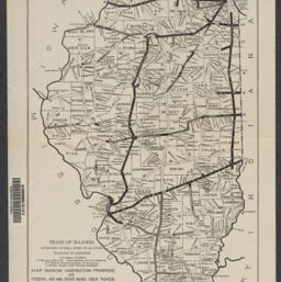
Map showing construction progress on federal aid and state bond issue roads / prepared by Bureau of Design, Dec. 8, 1921 ; drawn by G.W.R.
Permalink
https://digital.library.illinois.edu/items/6fc016f0-1f6a-013c-489c-02d0d7bfd6e4-e
No Copyright - United States
Descriptive Information
| Title | Map showing construction progress on federal aid and state bond issue roads / prepared by Bureau of Design, Dec. 8, 1921 ; drawn by G.W.R. |
| Creator | Illinois. Division of Highways |
| Scale | Scale [ca. 1:1,658,880] |
| Coordinates | W 91°30ʹ--W 87°30ʹ/N 42°30ʹ--N 37° |
| Place of Publication | Springfield (Ill.) |
| Publisher | State of Illinois, Department of Public Works and Buildings, Division of Highways |
| Date of Publication | 1922 |
| Extent | 1 map |
| Dimensions | 40 x 24 cm |
| Notes |
|
| Coverage-Spatial | Illinois |
| Language | English |
| Subject | Roads |
| Genre | |
| Rights | No Copyright - United States |
| Type | Cartographic material |
| Repository | Map Library |
| Local Bib ID | 99459439012205899 |
| Collection Title | 1920s Maps |
| Collection | 1920s Maps |
Download Options
|
Map showing construction progress on federal aid and state bond issue roads / prepared by Bureau of Design, Dec. 8, 1921 ; drawn by G.W.R. |
Contact us
for questions and to provide feedback.