
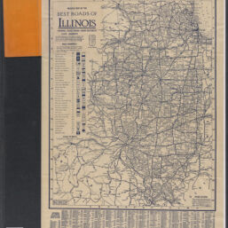
Road map of Illinois : showing paved roads, highway numbers, mileage between towns, pole markings, index of towns, populations / published by the Clason Map Co., Chicago
Permalink
https://digital.library.illinois.edu/items/6fcfd240-1f6a-013c-489c-02d0d7bfd6e4-6
No Copyright - United States
Descriptive Information
| Title | Road map of Illinois : showing paved roads, highway numbers, mileage between towns, pole markings, index of towns, populations / published by the Clason Map Co., Chicago |
| Alternative Title | Title within map border: Mileage map of the best roads of Illinois, showing paved roads, road distances, state highways |
| Creator | Clason Map Co. |
| Scale | Scale approximately 1:1,060,000 |
| Coordinates | W 92°58ʹ--W 87°07ʹ/N 42°30ʹ--N 36°58ʹ |
| Place of Publication | Chicago (Ill.) |
| Publisher | Clason Map Co. |
| Date of Publication | 1920-1929 |
| Extent | 1 map |
| Dimensions | 60 x 47 cm, folded in cover 19 x 11 cm |
| Notes |
|
| Coverage-Spatial | Illinois |
| Language | English |
| Subject | Roads |
| Genre | |
| Rights | No Copyright - United States |
| Type | Cartographic material |
| Repository | Map Library |
| Local Bib ID | 99802903012205899 |
| Collection Title | 1920s Maps |
| Collection | 1920s Maps |
Download Options
|
99802903012205899-001 | |
|
99802903012205899-002 |
Contact us
for questions and to provide feedback.