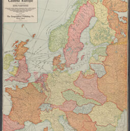
| Title | The Hudson dispatch [world map] ; Central Europe : showing the reconstructed and newly formed countries : British Isles, France, Belgium, Netherlands, Norway, Sweden, Denmark, Germany, Austria, Hungary, Switzerland, Italy, Finland, Russia, Baltic provinces, Lithuania, Poland, Czecho-Slovakia, Jugo-Slavia, Ukrainia, Serbia, Roumania, Bulgaria, Montenegro, Albania and other smaller countries |
| Alternative Title | Central Europe : showing the reconstructed and newly formed countries : British Isles, France, Belgium, Netherlands, Norway, Sweden, Denmark, Germany, Austria, Hungary, Switzerland, Italy, Finland, Russia, Baltic provinces, Lithuania, Poland, Czecho-Slovakia, Jugo-Slavia, Ukrainia, Serbia, Roumania, Bulgaria, Montenegro, Albania, and other smaller countries 2 |
| Notes | - Engraved, published and copyrighted by the Geographical Publishing Co. ; [prepared for] the Hudson dispatch.
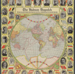
- World map shows steamship routes, exploration routes, and international borders.
- "Will keep you well informed on the news of your own state. The Dispatch covers its own field better than any other newspaper, besides which it gives the news of the county and state in its important essentials."
- Relief shown by hachures.
- "Copyright 1920, by the Geographical Publishing Co., Chicago, Illinois."
- "Copyright 1921, by the Geographical Publishing Company, Chicago, Ill."
- "Photographs copyrighted by Underwood & Underwood and International Film Service."
- World map includes notes, illustrations of clocks showing time zones and, with color illustrations of corresponding flags, portraits of the following leaders: Field Marshal Douglas Haig (UK), King George V (UK), Admiral David Beatty, General John J. Pershing (U.S.), President Warren G. Harding, Admiral William S. Sims (U.S.), Marshal Ferdinand Foch (France), Prime Minister Georges Clemenceau (France), President Alexander Millerand (France), President Belisario Porras (Panama), General Armando Diaz (Italy), King Victor Emanuel III (Italy), King Constantine (Greece), President Nikolai Lenine (Soviet Union), Minister of War Leon Trotsky (Russia), King Alexander I (Serbia), President Joseph Pilsudski (Poland), President Álvaro Obregón (Mexico), King Albert (Belgium), General Jacques (marshal of Belgium), President A. Stulgenskis (Lithuania), King Ferdinand (Roumania), Emperor Yoshihito (Japan), Lieutenant-General Takeji Nara (Japan), President António José de Almeida (Portugal), Admiral Horthy (regent for Hungary), President Thos. G. Masaryk (Czechoslovakia), King Haakon VII (Norway), King Gustaf V (Sweden), King Christian X (Denmark), President Edmund Schulthess (Switzerland), President Michael Haninish (Austria), President Frederick Ebert (Germany), King Boris III (Bulgaria), Sultan Mohammed VI (Turkey), King Alfonso XIII (Spain), Queen Wilhelmina (Holland), President Sun Yat Sen (China).
- "This stimulating map attempts to distill nearly the entire Eurocentric world polity into a single view. Flanked by a 'who's who' of political and military leaders, including pre-Soviet Lenin, Sun Yat Sen and Victor Emanuel, the somber, uniformed looks and bold symbolism reflect the serious attitude taken toward international politics and world organization following the First World War. Winners of the conflict, like the United States, France and Great Britain, are proudly displayed on top, while losers such as Germany, Bulgaria, Austria and Turkey are relegated to the bottom. Africa and South America are only marginally represented, as most of their landmass was under the colonial occupation of a European power at the time. A review of the political leaders is an interesting exercise - Wilhelmina would lead the Dutch through both world wars, Gustav V oversaw Sweden's transition to a democratic country, and Leon Trotsky would be brutally assassinated by the KGB. The map itself is also very informative, listing navigation distances between ports, exploration routes, time zones and the length of days relative to latitude. On the verso is a map of Central Europe showing borders after the Treaty of Versailles. Further modifications to the borders across Europe would again be necessary in a few short decades."--Edited description of Curtis Wright Maps.
|