
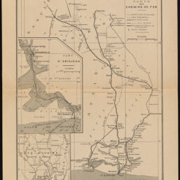
Le Projet de Chemin de Fer de la Côte d'Ivoire et le Port de Bingerville
Permalink
https://digital.library.illinois.edu/items/7338a350-3dcb-013b-c8a3-02d0d7bfd6e4-b
This item is in the public domain.
Descriptive Information
| Title | Le Projet de Chemin de Fer de la Côte d'Ivoire et le Port de Bingerville |
| Creator | Barralier, Emmanuel |
| Date | 1900 |
| Dimensions | 32.5 x 24 cm |
| Publisher | Bulletin de l'Afrique Française |
| Cartographic Scale | 1:500,000 |
| Notes | V. 10 , No. 2, after p. 60. |
| Coverage-Spatial | Africa, West |
| Genre | Maps |
| Language | French |
| Physical Location | Professor Thomas Bassett Personal Collection |
| Map ID | afm0003487 |
| Rights | No Copyright - United States |
| Rights Description | This item is in the public domain. |
| Collection Title | Maps of Africa to 1900 |
| Repository | Rare Book & Manuscript Library |
| Type | Cartographic material |
| Collection | Maps of Africa to 1900 |
Download Options
|
Le Projet de Chemin de Fer de la Côte d'Ivoire et le Port de Bingerville |
Contact us
for questions and to provide feedback.