
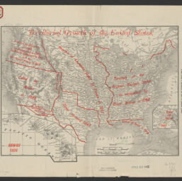
Territorial growth of the United States
Permalink
https://digital.library.illinois.edu/items/92efe890-3d7b-013d-4df4-02d0d7bfd6e4-7
No Copyright - United States
Descriptive Information
| Title | Territorial growth of the United States |
| Creator | Rand McNally and Company |
| Scale | Scale [1:15,269,760]. 241 miles to 1 in |
| Coordinates | W 124⁰45ʹ--W 67⁰00ʹ/N 49⁰--N 20⁰ |
| Place of Publication | Chicago (Ill.) |
| Publisher | Rand McNally and Company |
| Date of Publication | 1889 |
| Extent | 1 map color |
| Dimensions | 24 x 31 cm. |
| Notes |
|
| Language | English |
| Subject | |
| Genre | Maps |
| Rights | No Copyright - United States |
| Type | Cartographic material |
| Repository | Map Library |
| Local Bib ID | 99162257512205899 |
| Collection Title | American Empire Maps |
| Collection | American Empire Maps |
Download Options
|
99162257512205899-00000001 | |

|
99162257512205899-00000002 |
Contact us
for questions and to provide feedback.