
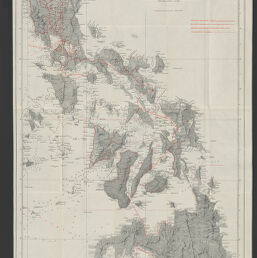
Progress map of Signal Corps telegraph lines & cables in the military division of the Philippines : based on map of Montero y Gay, issued by the Military Information Bureau, Adjutant General's Office / reproduced under the direction of Brigadier General A.W. Greely, chief signal officer, U.S. Army.
Permalink
https://digital.library.illinois.edu/items/933eb3e0-3d7b-013d-4df4-02d0d7bfd6e4-b
No Copyright - United States
Descriptive Information
| Title | Progress map of Signal Corps telegraph lines & cables in the military division of the Philippines : based on map of Montero y Gay, issued by the Military Information Bureau, Adjutant General's Office / reproduced under the direction of Brigadier General A.W. Greely, chief signal officer, U.S. Army. |
| Creator | United States. Army. Signal Corps. |
| Contributor | Greely. A. W. (Adolphus Washington). 1844-1935. |
| Scale | Scale approximately 1:1,640,000 |
| Coordinates | E 119°38ʹ--E 126°54ʹ/N 19°15ʹ--N 4°00ʹ |
| Place of Publication | Washington (D.C.) |
| Publisher | United States. Government Printing Office |
| Date of Publication | 1901 |
| Extent | 1 map : color |
| Dimensions | 104 x 49 cm |
| Notes |
|
| Coverage-Spatial | Philippines |
| Language | English |
| Subject | |
| Genre | Maps |
| Rights | No Copyright - United States |
| Type | Cartographic material |
| Repository | Map Library |
| Local Bib ID | 99955534899705899 |
| Collection Title | American Empire Maps |
| Collection | American Empire Maps |
Download Options
|
Progress map of Signal Corps telegraph lines & cables in the military division of the Philippines : based on map of Montero y Gay, issued by the Military Information Bureau, Adjutant General's Office / reproduced under the direction of Brigadier General A.W. Greely, chief signal officer, U.S. Army. |
Contact us
for questions and to provide feedback.