
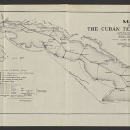
Map of the Cuban telegraph lines operated by the Signal Corps, U.S.A., June 30th, 1901 / prepared under the direction of Captain Otto A. Nesmith, Signal Corps, U.S. Army, Chief Signal Officer, Department of Cuba ; [drawn by T.M. Hollingsworth].
Map of the Cuban telegraph lines operated by the Signal Corps, United States of America, June 30, 1901
Permalink
https://digital.library.illinois.edu/items/934405b0-3d7b-013d-4df4-02d0d7bfd6e4-9
No Copyright - United States
Descriptive Information
| Title | Map of the Cuban telegraph lines operated by the Signal Corps, U.S.A., June 30th, 1901 / prepared under the direction of Captain Otto A. Nesmith, Signal Corps, U.S. Army, Chief Signal Officer, Department of Cuba ; [drawn by T.M. Hollingsworth]. |
| Alternative Title | Map of the Cuban telegraph lines operated by the Signal Corps, United States of America, June 30, 1901 |
| Creator | United States. Army. Signal Corps. |
| Scale | Scale approximately 1:2,600,000 |
| Coordinates | W 85°10ʹ--W 73°55ʹ/N 23°28ʹ--N 19°37ʹ |
| Place of Publication | Washington (D.C.) |
| Publisher | United States. Government Printing Office |
| Date of Publication | 1901 |
| Extent | 1 map : color |
| Dimensions | 19 x 46 cm |
| Notes |
|
| Coverage-Spatial | Cuba |
| Language | English |
| Subject | |
| Genre | Maps |
| Rights | No Copyright - United States |
| Type | Cartographic material |
| Repository | Map Library |
| Local Bib ID | 99955535169005899 |
| Collection Title | American Empire Maps |
| Collection | American Empire Maps |
Download Options
|
Map of the Cuban telegraph lines operated by the Signal Corps, U.S.A., June 30th, 1901 / prepared under the direction of Captain Otto A. Nesmith, Signal Corps, U.S. Army, Chief Signal Officer, Department of Cuba ; [drawn by T.M. Hollingsworth]. |
Contact us
for questions and to provide feedback.