
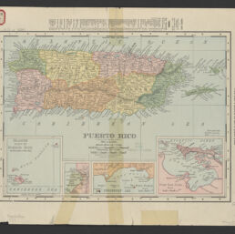
Puerto Rico
Permalink
https://digital.library.illinois.edu/items/9a806fd0-9dc3-013c-4aba-02d0d7bfd6e4-6
No Copyright - United States
Descriptive Information
| Title | Puerto Rico |
| Creator | Rand McNally and Company |
| Scale | Scale [ca. 1:760,320]. Statute miles, 12 = 1 in. |
| Coordinates | (W 67°20ʹ--W 65°10ʹ/N 18°40ʹ--N 17°10ʹ) |
| Place of Publication | Chicago (Ill.) |
| Publisher | Rand McNally & Co. |
| Date of Publication | 1899 |
| Extent | 1 map : hand colored |
| Dimensions | 22 x 31 cm |
| Notes |
|
| Coverage-Spatial | Puerto Rico |
| Genre | Maps |
| Rights | No Copyright - United States |
| Type | Cartographic material |
| Repository | Map Library |
| Local Bib ID | 99162077912205899 |
| Collection Title | American Empire Maps |
| Collection | American Empire Maps |
Download Options
|
99162077912205899-001 | |
|
99162077912205899-002 |
Contact us
for questions and to provide feedback.