
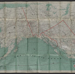
The map of maps : Alaska and British Columbia showing the Yukon, Cariboo, Cassiar, with a portion of the Kootenay gold fields
Permalink
https://digital.library.illinois.edu/items/9ab96e10-9dc3-013c-4aba-02d0d7bfd6e4-e
No Copyright - United States
Descriptive Information
| Title | The map of maps : Alaska and British Columbia showing the Yukon, Cariboo, Cassiar, with a portion of the Kootenay gold fields |
| Alternative Title |
|
| Creator | Millroy, J. J. |
| Scale | Scale approximately 1:4,000,000 |
| Coordinates | (W 174°--W 105°/N 71°--N 44°) |
| Place of Publication |
|
| Publisher | J.J. Millroy |
| Date of Publication | 1898 |
| Extent | 1 map : color |
| Dimensions | 57 x 93 cm, folded in folder to 16 x 10 cm |
| Notes |
|
| Coverage-Spatial | |
| Subject | Mines and mineral resources |
| Genre | Maps |
| Rights | No Copyright - United States |
| Type | Cartographic material |
| Repository | Map Library |
| Local Bib ID | 99587003912205899 |
| Collection Title | American Empire Maps |
| Collection | American Empire Maps |
Download Options
|
99587003912205899-001 | |

|
99587003912205899-002 | |

|
99587003912205899-003 | |
|
99587003912205899-004 | |

|
99587003912205899-005 | |

|
99587003912205899-006 |
Contact us
for questions and to provide feedback.