
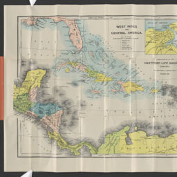
War map of the West Indies
Permalink
https://digital.library.illinois.edu/items/9b5b4a40-9dc3-013c-4aba-02d0d7bfd6e4-5
No Copyright - United States
Descriptive Information
| Title | War map of the West Indies |
| Alternative Title | Title within map border:West Indies and Central America |
| Creator | Hartford Life Insurance Company |
| Scale | Scale approximately 1:9,150,000 |
| Coordinates | (W° 93--W° 59/N° 31--N 7°) |
| Place of Publication | Hartford (Conn.) |
| Publisher | Hartford Life Insurance Co. |
| Date of Publication | 1898 |
| Extent | 1 map : color |
| Dimensions | 30 x 39 cm, in cover 14 x 7 cm |
| Notes |
|
| Coverage-Spatial | |
| Subject | Spanish-American War, 1898 |
| Associated Entities | J.C. Lutz Lith. Co. |
| Genre | Maps |
| Rights | No Copyright - United States |
| Type | Cartographic material |
| Repository | Map Library |
| Local Bib ID | 99955482519605899 |
| Collection Title | American Empire Maps |
| Collection | American Empire Maps |
Download Options
|
99955482519605899-001 | |

|
99955482519605899-002 |
Contact us
for questions and to provide feedback.