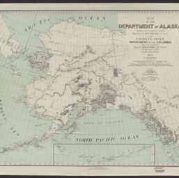
The items in the Digital Collections of the University of Illinois Urbana-Champaign Library contain materials which represent or depict sensitive topics or were written from perspectives using outdated or biased language. The Library condemns discrimination and hatred on any grounds. As a research library that supports the mission and values of this land grant institution, it is incumbent upon the University Library to preserve, describe, and provide access to materials to accurately document our past, support learning about it, and effect change in the present. In accordance with the American Library Association’s Freedom to Read statement, we do not censor our materials or prevent patrons from accessing them.
United States. Army. Department of the Columbia. Engineer Office
Scale
Scale approximately 1:3,150,000
Coordinates
(E 178°--W 116°/N 72°--N 52°)
Place of Publication
Washington (D.C.)
Publisher
United States. War Department
Julius Bien & Co.
Norris Peters Co.
Date of Publication
1902
Extent
1 map : color
Dimensions
66 x 83 cm
Notes
Relief shown by hachures and spot heights.
Shows locations of railroads, telegraph lines, wagon roads, post offices, trails, light houses, and forts occupied as of September 1, 1902.
Includes list of authorities.
Inset: Aleutian Islands.
Projected and compiled by order of Brig. Gen. G.M. Randall, U.S.A. in the Engineer Office, Department of the Columbia ; under the direction of Maj. W.R. Abercrombie, 30th Infantry, acting engineer officer ; by H.L. Gilbert, Jr. C.E
Coverage-Spatial
Alaska
Subject
Roads
Railroads
Associated Entities
Randall, G. M.(George Morton),1841-1918.
Abercrombie, W. R.(William Ralph),1857-1943.
Gilbert, H. L.
United States. Adjutant-General's Office. Military Information Division