
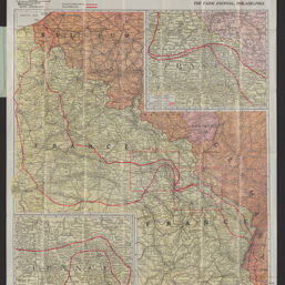
Farm Journal map of the American battle-front : showing the farthest advance of the Germans in 1914, and the battle line as it now stands
Permalink
https://digital.library.illinois.edu/items/9bde17a0-78dd-013b-43d9-02d0d7bfd6e4-2
No Copyright - United States
Descriptive Information
| Title | Farm Journal map of the American battle-front : showing the farthest advance of the Germans in 1914, and the battle line as it now stands |
| Alternative Title |
|
| Creator | Rand McNally and Company |
| Scale | Scale 1:633,600. 1 in. = 10 miles |
| Coordinates | E 2°--E 8°/N 52°--N 47° |
| Place of Publication | Philadelphia (Pa.) |
| Publisher | Farm Journal, Inc. |
| Date of Publication | 1918 |
| Extent | 1 map : color |
| Dimensions | 71 x 60 cm, folded in cover 17 x 11 cm + $e1 envelope (12 x 18 cm) |
| Notes |
|
| Coverage-Spatial | |
| Language | English |
| Subject | |
| Associated Entities | Farm Journal, Inc. |
| Genre | Maps |
| Rights Description | No Copyright - United States |
| Type | Cartographic material |
| Repository | Map Library |
| Local Bib ID | 99955226322305899 |
| Collection Title | World War I Maps |
| Collection | World War I Maps |
Download Options
|
99955226322305899-001 | |

|
99955226322305899-002 | |

|
99955226322305899-003 | |

|
99955226322305899-004 |
Contact us
for questions and to provide feedback.