
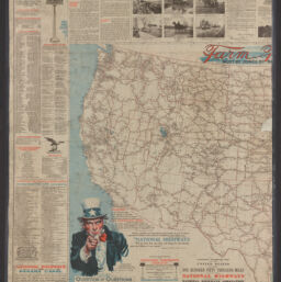
National highways map of the United States showing one hundred fifty thousand miles of national highways proposed by the National Highways Association
Permalink
https://digital.library.illinois.edu/items/a1117e00-88dd-013a-c212-02d0d7bfd6e4-8
No Copyright - United States
Descriptive Information
| Title | National highways map of the United States showing one hundred fifty thousand miles of national highways proposed by the National Highways Association |
| Creator | National Highways Association. |
| Contributor | Mulford, John C. |
| Scale | Scale [ca. 1:3,800,000] |
| Coordinates | (W 125⁰--W 67⁰/N 49⁰--N 25⁰) |
| Place of Publication | Washington (D.C.) |
| Publisher | National Highways Association |
| Date of Publication | 1918 |
| Extent | 1 map : color |
| Dimensions | 76 x 125 cm, on sheet 102 x 157 cm |
| Notes |
|
| Coverage-Spatial | United States |
| Language | English |
| Subject | |
| Genre | |
| Rights Description | No Copyright - United States |
| Type | Cartographic material |
| Repository | Map Library |
| Local Bib ID | 99162182012205899 |
| Collection Title | World War I Maps |
| Collection | World War I Maps |
Download Options
|
99162182012205899-001 | |

|
99162182012205899-002 | |

|
99162182012205899-003 |
Contact us
for questions and to provide feedback.