
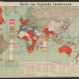
Karte von Englands Länderraub
Permalink
https://digital.library.illinois.edu/items/a12033f0-88dd-013a-c212-02d0d7bfd6e4-5
No Copyright - United States
Descriptive Information
| Title | Karte von Englands Länderraub |
| Alternative Title | Karte von Englands Länder-raub |
| Creator | Pharus-Verlag |
| Scale | Scale approximately 1:44,775,253 at equator |
| Coordinates | (W 180°--E 180°/N 73°--S 75°). |
| Place of Publication | Berlin (Germany) |
| Publisher | Pharus-Verlages G.m.b.H. |
| Date of Publication | |
| Extent | 1 map : color |
| Dimensions | 54 x 91 cm, on sheet 59 x 93 cm, folded in cover 21 x 13 cm |
| Notes |
|
| Coverage-Spatial | |
| Language | German |
| Subject | |
| Genre | |
| Rights Description | No Copyright - United States |
| Type | Cartographic material |
| Repository | Map Library |
| Local Bib ID | 99955038170205899 |
| Collection Title | World War I Maps |
| Collection | World War I Maps |
Download Options
|
99955038170205899-001 | |
|
99955038170205899-002 |
Contact us
for questions and to provide feedback.