
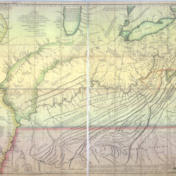
A topographical description of Virginia, Pennsylvania, Maryland, and North Carolina : comprehending the rivers Ohio, Kenhawa, Sioto, Cherokee, Wabash, Illinois, Mississippi, &c. the climate, soil and produce, whether animal, vegetable, or mineral ; the mountains, creeks, roads, distances, latitudes, &c. and of every part laid down in the annexed map / published by Thomas Hutchins, captain in the 60th regiment of foot ; with a plan of the rapids of the Ohio, a plan of the several villages in the Illinois country, a table of the distances between Fort Pitt and the mouth of the Ohio, all engraved upon copper ; and an appendix, containing Mr. Patrick Kennedy's Journal up the Illinois River, and a correct list of the different nations and tribes of Indians, with the number of fighting men, &c.
part of the river Mississippi, the whole of the Illinois River,...
Permalink
https://digital.library.illinois.edu/items/a197b2a0-994e-0134-2096-0050569601ca-5Descriptive Information
| Title | A topographical description of Virginia, Pennsylvania, Maryland, and North Carolina : comprehending the rivers Ohio, Kenhawa, Sioto, Cherokee, Wabash, Illinois, Mississippi, &c. the climate, soil and produce, whether animal, vegetable, or mineral ; the mountains, creeks, roads, distances, latitudes, &c. and of every part laid down in the annexed map / published by Thomas Hutchins, captain in the 60th regiment of foot ; with a plan of the rapids of the Ohio, a plan of the several villages in the Illinois country, a table of the distances between Fort Pitt and the mouth of the Ohio, all engraved upon copper ; and an appendix, containing Mr. Patrick Kennedy's Journal up the Illinois River, and a correct list of the different nations and tribes of Indians, with the number of fighting men, &c. |
| Title-Alternative |
|
| Author | Hutchins, Thomas, 1730-1789 |
| Coverage-Spatial | Illinois River |
| Subject | Statistics |
| Type | Cartographic material |
| Genre | Maps |
| Description |
|
| Dimensions | 91 x 109 cm |
| Date | 1778 |
| Contributors | Cheevers, T. |
| Scale | Scale ca. 1:1,270,000 |
| Repository | Map Library |
| Original Publisher | London |
| Collection Publisher | University of Illinois at Urbana-Champaign. Map Library |
| Call Number | X917.5 H97t 1778 Atlas |
| Source | Thos. Hutchins, 1778. |
| Language | English |
| Archival File Name | X917_5.tif |
| Collection Title | Historical Maps Online |
| Collection | Historical Maps Online |
Download Options
|
A topographical description of Virginia, Pennsylvania, Maryland, and North Carolina : comprehending the rivers Ohio, Kenhawa, Sioto, Cherokee, Wabash, Illinois, Mississippi, &c. the climate, soil and produce, whether animal, vegetable, or mineral ; the mountains, creeks, roads, distances, latitudes, &c. and of every part laid down in the annexed map / published by Thomas Hutchins, captain in the 60th regiment of foot ; with a plan of the rapids of the Ohio, a plan of the several villages in the Illinois country, a table of the distances between Fort Pitt and the mouth of the Ohio, all engraved upon copper ; and an appendix, containing Mr. Patrick Kennedy's Journal up the Illinois River, and a correct list of the different nations and tribes of Indians, with the number of fighting men, &c. |
Contact us
for questions and to provide feedback.