
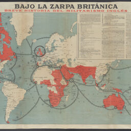
Bajo la zarpa británica : breve historia del militarismo inglés
Permalink
https://digital.library.illinois.edu/items/a52051b0-b639-013b-45f5-02d0d7bfd6e4-3
No Copyright - United States
Descriptive Information
| Title | Bajo la zarpa británica : breve historia del militarismo inglés |
| Creator | Haase, F. |
| Scale | Scale approximately 1:28,000,000 |
| Coordinates | W 180°--E 180°/N 80°--S 57° |
| Place of Publication | Spain |
| Publisher | Haase, F. |
| Date of Publication | 1918 |
| Extent | 1 map : color |
| Dimensions | 71.5 x 107.7 cm |
| Notes |
|
| Coverage-Spatial | British colonies |
| Language | Spanish |
| Subject | |
| Genre | |
| Rights Description | No Copyright - United States |
| Type | Cartographic material |
| Repository | Map Library |
| Local Bib ID | 99955189206705899 |
| Collection Title | World War I Maps |
| Collection | World War I Maps |
Download Options
|
Bajo la zarpa británica : breve historia del militarismo inglés |
Contact us
for questions and to provide feedback.