
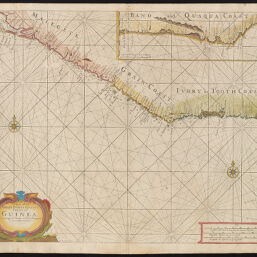
A Chart of the Grain Ivory and Quaqua Coasts in Guinea from Cape St. Anne to Teen Pequene.
Permalink
https://digital.library.illinois.edu/items/c0030540-7e27-0136-5134-0050569601ca-b
This item is in the public domain.
Descriptive Information
| Title | A Chart of the Grain Ivory and Quaqua Coasts in Guinea from Cape St. Anne to Teen Pequene. |
| Creator | JNo. Mount and Tho. Page |
| Date | 1751 |
| Dimensions | 43 x 52.5 cm |
| Cartographic Scale | 1:2,000,000 |
| Coverage-Spatial | Africa, West |
| Genre | Maps |
| Language | English |
| Source | |
| Physical Location | Professor Thomas Bassett Personal Collection |
| Map ID | afm0003368 |
| Rights | No Copyright - United States |
| Rights Description | This item is in the public domain. |
| Collection Title | Maps of Africa to 1900 |
| Repository | Rare Book & Manuscript Library |
| Type | Cartographic material |
| Collection | Maps of Africa to 1900 |
Download Options
|
afm0003368-001 | |
|
afm0003368-002 |
Contact us
for questions and to provide feedback.