
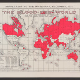
The blood-red world : map showing territory of the Earth directly affected by the Great War
Permalink
https://digital.library.illinois.edu/items/e0f69960-9e71-013a-c336-02d0d7bfd6e4-6
No Copyright - United States
Descriptive Information
| Title | The blood-red world : map showing territory of the Earth directly affected by the Great War |
| Creator | Southern Publishing Association |
| Scale | Scale approximately 1:140,000,000. At equator. |
| Coordinates | (W 180°--E 180°/N 80°--S 60°). |
| Place of Publication | Nashville (Tenn.) |
| Publisher | Southern Publishing Association |
| Date of Publication | 1914 |
| Extent | 1 map : color |
| Dimensions | 19 x 29 cm |
| Notes |
|
| Coverage-Spatial | Earth (Planet) |
| Language | English |
| Subject | World War, 1914-1918 |
| Genre | |
| Rights Description | No Copyright - United States |
| Type | Cartographic material |
| Repository | Map Library |
| Local Bib ID | 99954864004505899 |
| Collection Title | World War I Maps |
| Collection | World War I Maps |
Download Options
|
99954864004505899-001 | |

|
99954864004505899-002 |
Contact us
for questions and to provide feedback.