
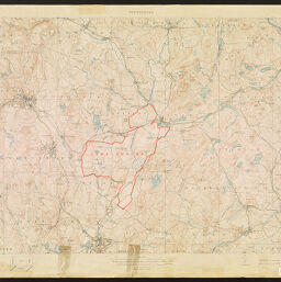
Camp Devens and vicinity
Permalink
https://digital.library.illinois.edu/items/ef2a0af0-17c7-0137-6b56-02d0d7bfd6e4-9
No Copyright - United States
Descriptive Information
| Title | Camp Devens and vicinity |
| Creator | Geological Survey (U.S.) |
| Contributor | Atwood, Wallace Walter |
| Scale | Scale 1:62,500 |
| Coordinates | (W 71°55'--W 71°20'/N 42°41'--N 42°24') |
| Place of Publication | Washington (D.C.) |
| Publisher | Geological Survey (U.S.) |
| Date of Publication | 1919 |
| Extent | 1 map, color |
| Dimensions | 49 x 73 cm |
| Notes |
|
| Coverage-Spatial | |
| Language | English |
| Subject | |
| Genre | Topographic maps |
| Rights Description | No Copyright - United States |
| Type | Cartographic material |
| Repository | Map Library |
| Local Bib ID | 1614195 |
| Collection Title | World War I Maps |
| Collection | World War I Maps |
Download Options
|
1614195-001 | |
|
1614195-002 |
Contact us
for questions and to provide feedback.