
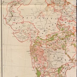
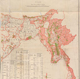
India showing government forests on 30th June 1919
Permalink
https://digital.library.illinois.edu/items/ef4db480-17c7-0137-6b56-02d0d7bfd6e4-a
No Copyright - United States
Descriptive Information
| Title | India showing government forests on 30th June 1919 |
| Alternative Title | India showing government forests on 30 June 1919 |
| Creator | Survey of India. Forest Map Office |
| Scale | Scale 1:3,041,280. 1 in. = 48 miles |
| Coordinates | (E 64°--E 102°/N 36°--N 8°) |
| Place of Publication | Dehra Dūn (India) |
| Publisher | Survey of India |
| Date of Publication | 1920 |
| Extent | 1 map on 2 sheets, color |
| Dimensions | 99 x 115 cm, on sheets 105 x 68 cm and 105 x 55 cm |
| Notes |
|
| Coverage-Spatial | |
| Language | English |
| Genre | Maps |
| Rights Description | No Copyright - United States |
| Type | Cartographic material |
| Repository | Map Library |
| Local Bib ID | 1921012 |
| Collection Title | World War I Maps |
| Collection | World War I Maps |
Download Options
|
1921012-001 | |
|
1921012-002 |
Contact us
for questions and to provide feedback.