
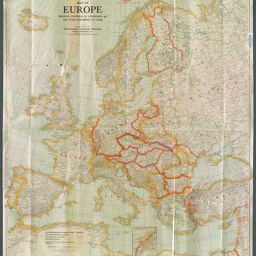
Map of Europe showing countries as established by the Peace Conference at Paris
Permalink
https://digital.library.illinois.edu/items/ef7c1a10-17c7-0137-6b56-02d0d7bfd6e4-d
No Copyright - United States
Descriptive Information
| Title | Map of Europe showing countries as established by the Peace Conference at Paris |
| Creator | Matthews-Northrup Company |
| Contributor | National Geographic Society (U.S.) |
| Scale | Scale 1:5,322,240. 84 miles = 1 in. |
| Coordinates | (W 30°--E 60°/N 72°--N 29°) |
| Place of Publication | Washington (D.C.) |
| Publisher | National Geographic Society (U.S.) |
| Date of Publication | 1920 |
| Extent | 1 map, color |
| Dimensions | 83 x 79 cm |
| Notes |
|
| Coverage-Spatial | Europe |
| Language | English |
| Genre | Thematic maps |
| Rights Description | No Copyright - United States |
| Type | Cartographic material |
| Repository | Map Library |
| Local Bib ID | 3998045 |
| Collection Title | World War I Maps |
| Collection | World War I Maps |
Download Options
|
Map of Europe showing countries as established by the Peace Conference at Paris |
Contact us
for questions and to provide feedback.