
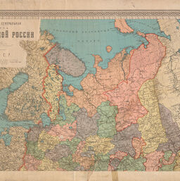
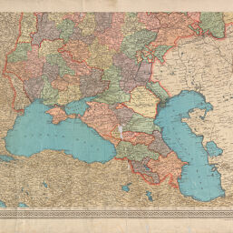
Nastolʹnai︠a︡ generalʹnai︠a︡ karta evropeĭskoĭ Rossii
Permalink
https://digital.library.illinois.edu/items/efd3f9b0-17c7-0137-6b56-02d0d7bfd6e4-4
No Copyright - United States
Descriptive Information
| Title | Nastolʹnai︠a︡ generalʹnai︠a︡ karta evropeĭskoĭ Rossii |
| Creator | 1-oe gosudarstvennoe kartograficheskoe zavedenie |
| Scale | Scale [1:4,200,000]. 1 in. = 100 versts. |
| Place of Publication | Petrograd (R.S.F.S.R.) |
| Publisher | Izdanie 1go gosudartv. kartografichesk. zavedenii︠a︡ byvsh. A. Ilʹina |
| Date of Publication | 1922 |
| Extent | 1 map, color |
| Dimensions | 95 x 75 cm on sheets 58 x 89 cm |
| Notes |
|
| Coverage-Spatial | Soviet Union, Western |
| Language | Russian |
| Genre | Thematic maps |
| Rights Description | No Copyright - United States |
| Type | Cartographic material |
| Repository | Map Library |
| Local Bib ID | 4001827 |
| Collection Title | World War I Maps |
| Collection | World War I Maps |
Download Options
|
4001827-001 | |
|
4001827-002 |
Contact us
for questions and to provide feedback.