
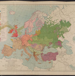
Map of the races of Europe and adjoining portions of Asia and Africa
Permalink
https://digital.library.illinois.edu/items/effb4a90-17c7-0137-6b56-02d0d7bfd6e4-c
No Copyright - United States
Descriptive Information
| Title | Map of the races of Europe and adjoining portions of Asia and Africa |
| Creator | Bumstead, Albert H. (Albert Hoit), 1875-1940 |
| Contributor | |
| Scale | Scale [ca. 1:9,500,000] |
| Coordinates | (W 40°--E 85°/N 80°--N 25°) |
| Place of Publication | Washington (D.C.) |
| Publisher | National Geographic Society (U.S.) |
| Date of Publication | 1919 |
| Extent | 1 map, color |
| Dimensions | 49 x 59 cm |
| Language | English |
| Genre | Thematic maps |
| Rights Description | No Copyright - United States |
| Type | Cartographic material |
| Repository | Map Library |
| Local Bib ID | 5185192 |
| Collection Title | World War I Maps |
| Collection | World War I Maps |
Download Options
|
Map of the races of Europe and adjoining portions of Asia and Africa |
Contact us
for questions and to provide feedback.