
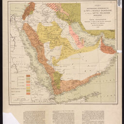
Arabia
Permalink
https://digital.library.illinois.edu/items/f03e0540-17c7-0137-6b56-02d0d7bfd6e4-4
No Copyright - United States
Descriptive Information
| Title | Arabia |
| Creator | Italy. Ministero delle colonie. Ufficio cartografico |
| Contributor | Dardano, A. |
| Scale | Scale 1:6,000,000 |
| Coordinates | (E 30°--E 60°/N 35°--N 10°) |
| Place of Publication | Florence (Italy) |
| Publisher | Ministero delle Colonie, Ufficio Cartografico |
| Date of Publication | 1918 |
| Extent | 1 map, color |
| Dimensions | 46 x 50 cm, on sheet 68 x 54 cm |
| Notes |
|
| Coverage-Spatial | Arabian Peninsula |
| Language | Italian |
| Genre | Maps |
| Rights Description | No Copyright - United States |
| Type | Cartographic material |
| Repository | Map Library |
| Local Bib ID | 7665960 |
| Collection Title | World War I Maps |
| Collection | World War I Maps |
Download Options
Contact us
for questions and to provide feedback.