


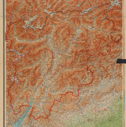
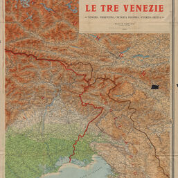
Carta ipsometrica, Le Tre Venezie
Permalink
https://digital.library.illinois.edu/items/f0549b80-17c7-0137-6b56-02d0d7bfd6e4-d
No Copyright - United States
Descriptive Information
| Title | Carta ipsometrica, Le Tre Venezie |
| Alternative Title | Tre Venezie |
| Creator | Istituto geografico De Agostini |
| Scale | Scale 1:250,000 |
| Coordinates | (E 10°20'--E 14°32'/N 47°20'--N 46°20') |
| Place of Publication | Novara (Italy) |
| Publisher | Istituto geografico De Agostini |
| Date of Publication | 1916-1919 |
| Extent | 1 map on 2 sheets, color |
| Dimensions | 89 x 129 cm, sheets 101 x 69 cm |
| Notes |
|
| Coverage-Spatial | |
| Language | Italian |
| Genre | Physical maps |
| Rights Description | No Copyright - United States |
| Type | Cartographic material |
| Repository | Map Library |
| Local Bib ID | 7668558 |
| Collection Title | World War I Maps |
| Collection | World War I Maps |
Download Options
|
7668558-001 | |
|
7668558-002 |
Contact us
for questions and to provide feedback.