


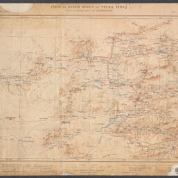
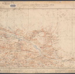
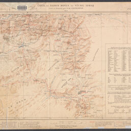
Carte du bassin moyen du Yéchil Irmaq
Permalink
https://digital.library.illinois.edu/items/f06ecaf0-17c7-0137-6b56-02d0d7bfd6e4-f
No Copyright - United States
Descriptive Information
| Title | Carte du bassin moyen du Yéchil Irmaq |
| Alternative Title |
|
| Creator | Jerphanion, Guillaume de, 1877-1948 |
| Contributor | Barrère, Henry |
| Scale | Scale 1:200,000 |
| Coordinates | (E 34°53ʹ--E 37°42ʹ/N 41°07ʹ--N 39°34ʹ) |
| Place of Publication | Paris (France) |
| Publisher | Barrère, Henry |
| Date of Publication | 1913 |
| Extent | 4 maps, color |
| Dimensions | 42 x 60 cm, on sheets 53 x 69 cm or smaller |
| Notes |
|
| Coverage-Spatial | Yesil River Watershed (Turkey) |
| Language | French |
| Genre | Maps |
| Rights Description | No Copyright - United States |
| Type | Cartographic material |
| Repository | Map Library |
| Local Bib ID | 7671429 |
| Collection Title | World War I Maps |
| Collection | World War I Maps |
Download Options
|
7671429-001 | |
|
7671429-002 | |

|
7671429-003 | |
|
7671429-004 |
Contact us
for questions and to provide feedback.