
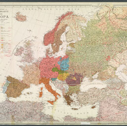
G. Freytags Völkerkarte von Europa
G. Freytag's Karte von Europa
Permalink
https://digital.library.illinois.edu/items/f0764df0-17c7-0137-6b56-02d0d7bfd6e4-1
No Copyright - United States
Descriptive Information
| Title | G. Freytags Völkerkarte von Europa |
| Alternative Title |
|
| Creator | Kartographische Anstalt Freytag und Berndt |
| Contributor | Haberlandt, Arthur |
| Scale | Scale 1:7,500,000 |
| Coordinates | (W 25°--E 82°/N 73°--N 25°) |
| Place of Publication | Vienna (Austria) |
| Publisher | Kartographische Anstalt Freytag und Berndt |
| Date of Publication | 1918 |
| Extent | 1 map, color |
| Dimensions | 65 x 79 cm |
| Notes |
|
| Language | German |
| Rights Description | No Copyright - United States |
| Type | Cartographic material |
| Repository | Map Library |
| Local Bib ID | 7674516 |
| Collection Title | World War I Maps |
| Collection | World War I Maps |
Download Options
|
G. Freytags Völkerkarte von Europa |
Contact us
for questions and to provide feedback.