
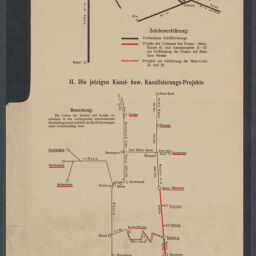
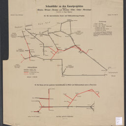
Schaubilder zu den Kanalprojekten zwischen Rhein-Weser-Donau und Donau-Elbe-Oder-Weichsel
Permalink
https://digital.library.illinois.edu/items/f0c7dd30-17c7-0137-6b56-02d0d7bfd6e4-d
No Copyright - United States
Descriptive Information
| Title | Schaubilder zu den Kanalprojekten zwischen Rhein-Weser-Donau und Donau-Elbe-Oder-Weichsel |
| Alternative Title |
|
| Creator | |
| Contributor | Langhans, Paul |
| Scale | Scale 1:5,000,000 |
| Place of Publication | Gotha (Germany) |
| Publisher | Justus Perthes (Firm : Gotha, Germany) |
| Date of Publication | 1916 |
| Extent | 4 maps on 2 sheets, color |
| Dimensions | on sheets 51 x 48 cm and 48 x 23 cm |
| Notes |
|
| Coverage-Spatial | |
| Language | German |
| Genre | Thematic maps |
| Rights Description | No Copyright - United States |
| Type | Cartographic material |
| Repository | Map Library |
| Local Bib ID | 7680570 |
| Collection Title | World War I Maps |
| Collection | World War I Maps |
Download Options
|
7680570-001 | |
|
7680570-002 |
Contact us
for questions and to provide feedback.