
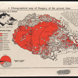
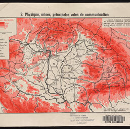
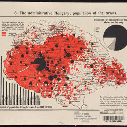
Ethnicity, transportation infrastructure, and mineral resources of the Kingdom of Hungary
Permalink
https://digital.library.illinois.edu/items/f1471ff0-17c7-0137-6b56-02d0d7bfd6e4-f
No Copyright - United States
Descriptive Information
| Title | Ethnicity, transportation infrastructure, and mineral resources of the Kingdom of Hungary |
| Alternative Title |
|
| Scale | Scale approximately 1:3,870,000. |
| Date of Publication | 1910-1919 |
| Extent | 3 maps, color |
| Dimensions | 17 x 26 cm, on sheets 23 x 31 cm, folded to 23 x 16 cm |
| Notes |
|
| Coverage-Spatial | Hungary |
| Language | English |
| Genre | Thematic maps |
| Rights Description | No Copyright - United States |
| Type | Cartographic material |
| Repository | Map Library |
| Local Bib ID | 7696046 |
| Collection Title | World War I Maps |
| Collection | World War I Maps |
Download Options
|
7696046-001 | |
|
7696046-002 | |
|
7696046-003 |
Contact us
for questions and to provide feedback.