
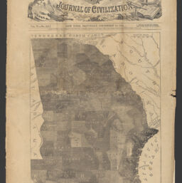
A chart map of Georgia showing the percentage of slaves in each county
Permalink
https://digital.library.illinois.edu/items/f9627c90-3d5b-013d-4df4-02d0d7bfd6e4-6
This item is in the public domain.
Descriptive Information
| Title | A chart map of Georgia showing the percentage of slaves in each county |
| Contributor | Harper's weekly |
| Scale | Scale approximately 1:2,100,000 |
| Coordinates | (W 85°36ʹ--W 80°45ʹ/N 35°00ʹ--N 30°21ʹ) |
| Place of Publication | New York (N.Y.) |
| Publisher | Harper & Brothers |
| Date of Publication | 1861 |
| Extent | 1 map |
| Dimensions | 28 x 24 cm, on sheet 42 x 29 cm |
| Notes |
|
| Coverage-Spatial | Georgia |
| Language | English |
| Subject | |
| Genre | Maps |
| Rights | No Copyright - United States |
| Rights Description | This item is in the public domain. |
| Type | Cartographic material |
| Repository | Map Library |
| Local Bib ID | 99955561623605899 |
| Collection Title | Civil War Maps |
| Collection | Civil War Maps |
Download Options
|
99955561623605899-00000001 | |
|
99955561623605899-00000002 |
Contact us
for questions and to provide feedback.