
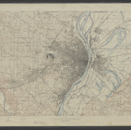
Saint Louis quadrangle, Missouri-Illinois /H.M. Wilson, geographer ; Chas E. Cooke, topographer in charge ; topography by Chas E. Cooke ... [et al.] ; control by U.S.C. and G.S. and Geo. T. Hawkins ; engraved Mar. 1904 by U.S.G.S.
Permalink
https://digital.library.illinois.edu/items/0d0cce70-4db9-013d-4df4-02d0d7bfd6e4-4
No Copyright - United States
Descriptive Information
| Title | Saint Louis quadrangle, Missouri-Illinois /H.M. Wilson, geographer ; Chas E. Cooke, topographer in charge ; topography by Chas E. Cooke ... [et al.] ; control by U.S.C. and G.S. and Geo. T. Hawkins ; engraved Mar. 1904 by U.S.G.S. |
| Alternative Title |
|
| Creator | Geological Survey (U.S.) |
| Scale | Scale 1:62,500 ; polyconic projection |
| Coordinates | (W 90⁰30ʹ00ʺ--W 90⁰00ʹ00ʺ/N 38⁰45ʹ00ʺ--N 38⁰30ʹ00ʺ) |
| Place of Publication | Washington (D.C.) |
| Publisher | Geological Survey (U.S.) |
| Date of Publication | 1925 |
| Extent | 1 map : color |
| Dimensions | 45 x 70 cm |
| Notes |
|
| Coverage-Spatial | |
| Language | English |
| Associated Entities | |
| Genre | |
| Rights | No Copyright - United States |
| Type | Cartographic material |
| Repository | Map Library |
| Local Bib ID | 99161418512205899 |
| Collection Title | River Maps |
| Collection | River Maps |
Download Options
|
99161418512205899-00000001 | |

|
99161418512205899-00000002 |
Contact us
for questions and to provide feedback.