


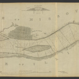
Map of the harbor of St. Louis, Mississippi River, Oct. 1837 /Surveyed by Lt. R.E. Lee, Corps of Engineers [and others] Drawn by Lt. Meigs, Corps of Engineers. W.J. Stone, sc.
Permalink
https://digital.library.illinois.edu/items/0d1fa180-4db9-013d-4df4-02d0d7bfd6e4-9
No Copyright - United States
Descriptive Information
| Title | Map of the harbor of St. Louis, Mississippi River, Oct. 1837 /Surveyed by Lt. R.E. Lee, Corps of Engineers [and others] Drawn by Lt. Meigs, Corps of Engineers. W.J. Stone, sc. |
| Creator | Lee, Robert E. (Robert Edward), 1807-1870 |
| Scale | Scale [ca. 1:316,800] |
| Coordinates | (W 92°07ʹ--W 92°07ʹ/N 38°25ʹ--N 38°25ʹ) |
| Place of Publication | Washington (D.C.) |
| Publisher | United States. Army. Corps of Engineers |
| Date of Publication | 1837 |
| Extent | 1 map : color |
| Dimensions | 42 x 108 cm |
| Notes |
|
| Coverage-Spatial | |
| Language | English |
| Subject | Harbors |
| Associated Entities | |
| Genre | Maps |
| Rights | No Copyright - United States |
| Type | Cartographic material |
| Repository | Map Library |
| Local Bib ID | 99399455512205899 |
| Collection Title | River Maps |
| Collection | River Maps |
Download Options
|
Map of the harbor of St. Louis, Mississippi River, Oct. 1837 /Surveyed by Lt. R.E. Lee, Corps of Engineers [and others] Drawn by Lt. Meigs, Corps of Engineers. W.J. Stone, sc. |
Contact us
for questions and to provide feedback.