
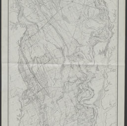
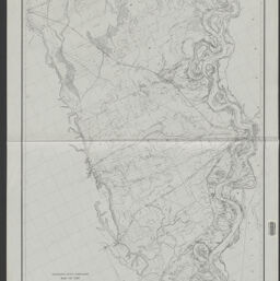
Map of the Saint Francis Basin in two parts /compiled and drawn, under the direction of Mason M. Patrick, Captain, Corps of Engineers, U.S.A., Secretary Mississippi River Commission, and George P. Howell, Captain, Corps of Engineers, U.S.A., Secretary Mississippi River Commission, by C.W. Clark, Assistant Engineer.
Permalink
https://digital.library.illinois.edu/items/0d567d40-4db9-013d-4df4-02d0d7bfd6e4-6
No Copyright - United States
Descriptive Information
| Title | Map of the Saint Francis Basin in two parts /compiled and drawn, under the direction of Mason M. Patrick, Captain, Corps of Engineers, U.S.A., Secretary Mississippi River Commission, and George P. Howell, Captain, Corps of Engineers, U.S.A., Secretary Mississippi River Commission, by C.W. Clark, Assistant Engineer. |
| Alternative Title | Saint Francis Basin |
| Creator | United States. Mississippi River Commission |
| Scale | Scale 1:126,720 1 half inch = 1 mile. |
| Place of Publication | St. Louis (Mo.) |
| Publisher | United States. Mississippi River Commision |
| Date of Publication | 1903 |
| Extent | 1 map on 2 sheets : on oilcloth |
| Dimensions | sheets 126 x 67 cm and 126 x 69 cm |
| Notes |
|
| Coverage-Spatial | |
| Language | English |
| Associated Entities | Clark, C. W. |
| Genre | |
| Rights | No Copyright - United States |
| Type | Cartographic material |
| Repository | Map Library |
| Local Bib ID | 99955557322505899 |
| Collection Title | River Maps |
| Collection | River Maps |
Download Options
|
99955557322505899-00000001 | |
|
99955557322505899-00000002 |
Contact us
for questions and to provide feedback.