
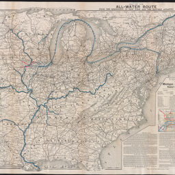
Map of the all-water route from the Mississippi to New York and the eastern Atlantic
Permalink
https://digital.library.illinois.edu/items/0f979dd0-9cc7-0139-7888-02d0d7bfd6e4-f
No Copyright - United States
Descriptive Information
| Title | Map of the all-water route from the Mississippi to New York and the eastern Atlantic |
| Creator | Michigan and Mississippi Canal Commission |
| Coordinates | W 97°39ʹ--W 69°15ʹ/N 47°33ʹ--N 29°00ʹ |
| Place of Publication |
|
| Publisher | |
| Date of Publication | 1885 |
| Extent | 1 map |
| Dimensions | 53 x 70 cm, on sheet 55 x 71 cm |
| Notes |
|
| Coverage-Spatial | Hennepin Canal (Ill.) |
| Subject | |
| Genre | Maps |
| Rights | No Copyright - United States |
| Type | Cartographic material |
| Repository | Map Library |
| Local Bib ID | 99825070112205899 |
| Collection Title | River Maps |
| Collection | River Maps |
Download Options
|
Map of the all-water route from the Mississippi to New York and the eastern Atlantic |
Contact us
for questions and to provide feedback.