
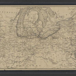
Map of the western states
Permalink
https://digital.library.illinois.edu/items/108bc620-c24f-013d-2ea7-02d0d7bfd6e4-7
No Copyright - United States
Descriptive Information
| Title | Map of the western states |
| Alternative Title | Cover title: Ensign & Thayer's map of the western states |
| Creator | Atwood, J. M., active 1840-1865 |
| Contributor | Ensigns & Thayer |
| Scale | 1:2,700,000 |
| Coordinates | (W 98°00ʹ--W 79°00ʹ/N 47°45ʹ--N 37°00ʹ) |
| Place of Publication | New York (N.Y.) |
| Publisher | Ensign, Thayer & Co. |
| Date of Publication | |
| Extent | 1 map : color |
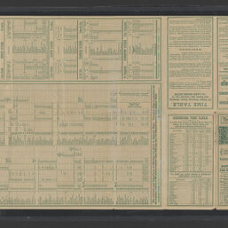
| Dimensions | 44 x 58 cm, folded in cover 15 x 9 cm + 1 text (33 pages : 15 cm) |
| Notes |
|
| Coverage-Spatial | Middle West |
| Language | English |
| Genre | Maps |
| Rights | No Copyright - United States |
| Type | Cartographic material |
| Repository | Map Library |
| Local Bib ID | 99954924926405899 |
| Collection Title | Railroad Maps |
| Collection | Railroad Maps |
Download Options
|
99954924926405899-00000001 | |
|
99954924926405899-00000002 |
Contact us
for questions and to provide feedback.