
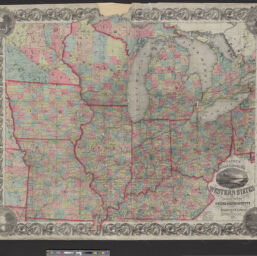
Colton's railroad & township map, Western States : compiled from the United States surveys
Permalink
https://digital.library.illinois.edu/items/1ce5bfc0-d050-013b-46a1-02d0d7bfd6e4-9
No Copyright - United States
Descriptive Information
| Title | Colton's railroad & township map, Western States : compiled from the United States surveys |
| Creator | J.H. Colton & Co. |
| Scale | Scale [ca. 1:1,550,000] |
| Coordinates | W 97°--W 78°/N 47°--N 36° |
| Place of Publication | New York (N.Y.) |
| Publisher | J.H. Colton & Co. |
| Date of Publication | 1855 |
| Extent | 1 map : color |
| Dimensions | 82 x 92 cm |
| Notes |
|
| Coverage-Spatial | Middle West |
| Language | English |
| Subject | Transportation |
| Genre | Maps |
| Rights | No Copyright - United States |
| Type | Cartographic material |
| Repository | Map Library |
| Local Bib ID | 99161579712205899 |
| Collection Title | Railroad Maps |
| Collection | Railroad Maps |
Download Options
|
Colton's railroad & township map, Western States : compiled from the United States surveys |
Contact us
for questions and to provide feedback.