
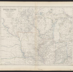
United States, North America : the north central section, comprising Michigan, Illinois, Wisconsin, Iowa, Indiana, Nebraska, Minnesota, and part of Missouri & Kentucky
Permalink
https://digital.library.illinois.edu/items/1cee36c0-d050-013b-46a1-02d0d7bfd6e4-1
No Copyright - United States
Descriptive Information
| Title | United States, North America : the north central section, comprising Michigan, Illinois, Wisconsin, Iowa, Indiana, Nebraska, Minnesota, and part of Missouri & Kentucky |
| Creator | Swanston, George H. |
| Scale | Scale [ca. 1:2,900,000] |
| Coordinates | W 101°--W 83°/N 48°--N 38° |
| Place of Publication |
|
| Publisher | A. Fullarton & Co. |
| Date of Publication | 1860 |
| Extent | 1 map : color |
| Dimensions | 38 x 48 cm |
| Notes |
|
| Coverage-Spatial | Middle West |
| Language | English |
| Subject | Northern Cross Railroad |
| Associated Entities | A. Fullarton & Co. |
| Genre | Maps |
| Rights | No Copyright - United States |
| Type | Cartographic material |
| Repository | Map Library |
| Local Bib ID | 99162006012205899 |
| Collection Title | Railroad Maps |
| Collection | Railroad Maps |
Download Options
|
United States, North America : the north central section, comprising Michigan, Illinois, Wisconsin, Iowa, Indiana, Nebraska, Minnesota, and part of Missouri & Kentucky |
Contact us
for questions and to provide feedback.