
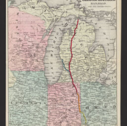
Map showing the Grand Rapids & Indiana Railroad and its connections
Permalink
https://digital.library.illinois.edu/items/1d2a0fa0-d050-013b-46a1-02d0d7bfd6e4-5
No Copyright - United States
Descriptive Information
| Title | Map showing the Grand Rapids & Indiana Railroad and its connections |
| Alternative Title | Grand Rapids and Indiana Railroad |
| Creator | G.W. & C.B. Colton & Co. |
| Scale | Scale [ca. 1:3,800,000] |
| Place of Publication | New York (N.Y.) |
| Publisher | G.W. & C.B. Colton & Co. |
| Date of Publication | 1871 |
| Extent | 1 map : color |
| Dimensions | 26 x 21 cm, on sheet 28 x 43 cm |
| Notes |
|
| Coverage-Spatial | Middle West |
| Language | English |
| Subject | |
| Genre | Thematic maps |
| Rights | No Copyright - United States |
| Type | Cartographic material |
| Repository | Map Library |
| Local Bib ID | 99162482612205899 |
| Collection Title | Railroad Maps |
| Collection | Railroad Maps |
Download Options
|
99162482612205899-001 | |
|
99162482612205899-002 | |

|
99162482612205899-003 |
Contact us
for questions and to provide feedback.